
Adventures
- Art, History & Culture
- ATV & Motorsports
- Birding & Wildlife
- Clamming
- Crabbing
- Cycling
- Entertainment and Nightlife
- Fishing
- Fishing by Style
- Forest Bathing & Mindfulness
- Gaming
- Golfing
- Hiking & Walking
- Lighthouses
- Ocean Life & Tidepooling
- Our Complete Guide to Forest Bathing
- Running
- Scenic Drives
- Shopping
- State Parks and National Lands
- Storm Watching
- Theatres
- Undeveloped Beaches
- Untamed Dunes
- Water Recreation
Hiking & Walking
TAKE A HIKE! LITERALLY!
Coos Bay, North Bend and Charleston in Coos County are an adventure waiting to happen. Grab your hiking boots and take in nature. There are many levels of difficulty, so whatever your skill level, we think you’ll find a way to breathe in the fresh air and explore.
We have a whole system of hiking trails in the immediate and surrounding area, but listed below are some of our favorites:

Oregon Coast Trail (Sunset Bay to Cape Arago)
Take Cape Arago Highway west from Charleston and you’ll find four miles of trails (one way) that trace a path along one of Oregon’s most spectacular stretches of coastline. From Sunset Bay, the trail winds around the coastal bluffs, offering spectacular views of the rugged, cliff-lined Pacific Ocean. It then runs past Shore Acres Botanical Gardens and the Simpson Reef viewing area before ending at the captivating Cape Arago State Park. Visit the Oregon Coast Trail website (Sunset Bay to Cape Arago, Segment 7) . Click here for a trail map.
Know Before You Go
- No animals permitted outside of vehicles in Shore Acres State Park and formal gardens, with the exception of service animals.
- Hikers, with dogs, already on the Oregon Coast Trail (the section of the trail that goes from Sunset Bay State Park to Cape Arago State Park, through Shore Acres State Park) may continue along the trail through Shore Acres State Park but dogs must stay on the trail and/or parking lot area only. The trail does not include the area around the Observation Building or bathroom areas and definitely does not include the gardens.
- Hikers cannot drive into Shore Acres and park their car to start on the trail with their dogs. There are plenty of areas to get on the trail along Cape Arago Highway including Sunset Bay State Park, Cape Arago State Park, the Lighthouse Overlook, and Simpson Reef/Shell Island Overlook.
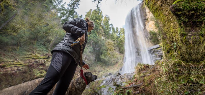
Golden & Silver Falls State Natural Area
Located almost an hour by car from Coos Bay at the end of Coos River Highway, Golden and Silver Falls is 24 miles off Highway 101 (Directions Here! ). A hidden gem in the dense coastal forests of southwest Oregon, Golden and Silver Falls State Natural Area may be hard to find, but it’s well worth the drive. A small parking and picnic area is located along the banks of Glenn and Silver Creeks, set in an old-growth forest of Douglas fir, Big Leaf Maple and Oregon Myrtle trees. Hiking trails wind through scenic canyons to each of the waterfalls, which plunge over sheer rock cliffs to moss-covered boulders 100 feet below. Hike 1.4 miles to the top of Golden Falls to get an eagle’s-eye view of the cascading waterfall and giant old-growth firs and cedars. Visit the Golden & Silver Falls Page on the Oregon State Parks website.
Bluebill Trail
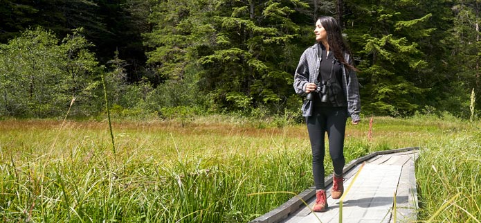
Located off Horsfall Road in the Oregon National Dunes Recreation Area just out of North Bend, this trail loops around a seasonal lake which is home to different species of birds and aquatic animals. At times, it looks like a grassy meadow and at other times, lake waters lap at the boardwalks. The eastern portion of the trail provides views of Bluebill Lake as it winds through Western hemlock trees and huckleberry and salal bushes. At the southern end of the lake, an extensive boardwalk protects the wetlands while allowing you to look closely for tadpoles and aquatic insects. The western part of the trail divides, giving you a choice of following the edge of the lake for a look at marsh plants and animal tracks, or following a parallel trail through open shorepine forest. Either route has good birding opportunities. Bring your camera and binoculars to view the sights. Visit the USDA Forest Service website for Bluebill Trail information.
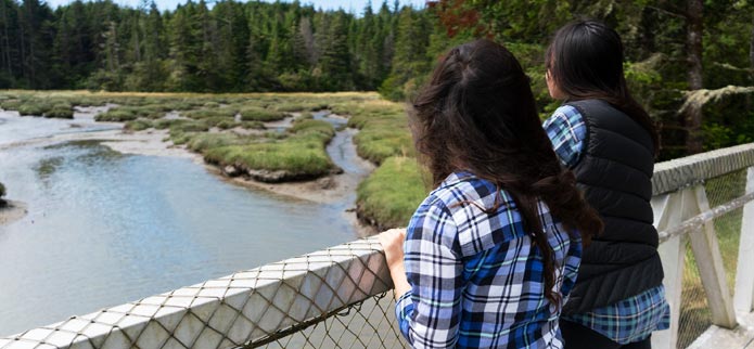
Estuary Study Trails
South Slough National Estuarine Research Reserve is located off Cape Arago Highway south of Charleston along Seven Devils Road. The Reserve covers 19,000 acres and offers hiking trails for all ability levels. Beginning in the uplands, this trail system follows Hidden Creek down the valley to the slough. After crossing the creek a few times the trail turns into a boardwalk that winds through fresh and saltwater marshes, including a portion called the skunk cabbage walk. Vegetation includes salmonberry, thimbleberry, Lyngby’s Sedge, and eelgrass. The “Saltwater Overlook” and “Lookout” offer views of mudflats and an open-water channel, and are ideal for wildlife observation. On the edge of the estuary are several trails that lead to the shoreline including Rhodes Dike, Sloughside Pilings and the Marsh trail. Heading back towards the interpretive center is the Big Cedar trail which has remnants of the former train trestle. Visit the South Slough Reserve webpage for more information. Click here for the Estuary Study Trails map (pdf).
Take a Virtual Tour of the South Slough Estuary Trails with Rick Dancer
John Dellenback Dunes Trail
Part of the Oregon Dunes National Recreation Area where motorized vehicles are prohibited. 2.7 Miles of the Dellenback trail leads to the beach, but the hike will seem longer as hikers are walking on soft, open sand. There is also an easier interpretive loop hike.
Empire Lakes Trail
4 miles of paved and 1.5 miles of dirt paths around Upper and Lower Empire Lakes in Coos Bay.
Millicoma Marsh
.5 mile loop with interpretive birding trail
Mingus Park
1 mile trail in Coos Bay’s city park that is paved, dirt and gravel, includes a secluded Zen garden, a Japanese inspired bridge over the pond in the middle of park, and an outdoor stage for musical events.
North Spit of Coos Bay Trail System
Made up of open sand dunes, forested islands, and wetlands, the North Spit of Coos Bay is at the southern-most end of a series of sand dunes extending along the Oregon coastline from Florence to Coos Bay. There are 10 miles of hiking/horse trails, sand driving roads, an undeveloped staging area and miles of beach waiting for you to explore. The North Spit of Coos Bay is home to the threatened western snowy plover. From March 15 to September 15 each year, access restrictions are in place on the dry sand along the ocean shore to protect the nesting birds.
Simpson Park/Ferry Road
1 mile loops in North Bend city park with disk golf, playground and other amenities.
Sawmill & Tribal Trail
The Sawmill & Tribal Trail can be accessed from many points around town, so check out as much of it as you have time and energy for. We hope you will enjoy learning more about the colorful past of the Coos Bay and North Bend area.
Be sure to wear comfortable and appropriate gear, including a helmet while biking, and always carry water.