
How to Find an Epic View of the Cape Arago Lighthouse
The Oregon Coast is known for its natural beauty and there is no greater way to experience the unique nature of the Pacific Coast than along the Cape Arago Beach Loop. This short drive is the perfect way to have the quintessential Oregon Coast experience with stunning beaches, state parks, spectacular scenery along with the alluring sounds of waves crashing and sea lions barking.
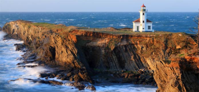
The Cape Arago Lighthouse near Charleston, Oregon is one of the iconic sites travelers will see along the way and is visible from multiple vista points. It is one of the most photographed lighthouses on the West Coast and listed on the National Register of Historic Places. The history of the Cape Arago Lighthouse goes back to 1866 when Coos Bay was one of the most active harbors on the West Coast and there was a need for a lighthouse to guide ships carrying lumber and coal into our bay.
Though images of The Cape Arago Lighthouse are posted everywhere, the lighthouse itself remains a mystery to many. It is no longer in operation nor is it open to the public. And yet, it still has a commanding presence and simple beauty making it the star of photographs and journals from travelers from around the world! The lighthouse stands on Chief’s Island at Point Gregory but visitors are no longer allowed on the island and is now private property.
Visitors can view and photograph the Cape Arago Lighthouse from a number of vista points* along Cape Arago Highway and there are great views from Lighthouse Beach , though you’ll have to hike on the Oregon Coast Trail to get there). “Great, calendar or postcard quality views from several locations around the Lighthouse, even though you cannot actually, physically get to the lighthouse yourself,” says The Oregon Coast Digest. “Well worth hiking the trails just south to get some special views and the beach, Lighthouse Beach, adjacent on the south is wonderful to visit and great for surfing.” If you’re not up for the hike, you may choose to kayak to Lighthouse Beach.
*Directions to the vista point: From Highway 101 in Coos Bay, head west on Newmark Street. Newmark Street will become eventually turn into Cape Arago Highway. Once you pass Sunset Bay State Park, you should see an entrance on the left to a camping area. You are now getting close and there will be a pullout for parking on the right. From here you can walk to a viewpoint where you can see the Cape Arago Lighthouse in the distance.
**Tips if you go: **
- Dress in layers and bring warm clothing, even in summer and fall. The Oregon Coast temperature is known to fluctuate.
- You will obviously get a much better view if you are going on a clear, sunny day. Check the weather before you go.
- Is fog getting in the way? Don’t worry, it usually will burn off once the sun comes out.
- Wear hiking shoes if you plan to get an even better view.
- If you plan to take pictures, bring a high-powered lens to get close-ups and/or binoculars.
- Download our PDF Guide for the Cape Arago Beach Loop
Have fun exploring! Other local lighthouses to look for on your trip include Umpqua River Lighthouse, Coquille River Light, Cape Blanco Lighthouse.
How to Explore The Cape Arago Beach Loop
From Hwy 101, head west on Newmark Avenue (just south of the Mill Casino). Follow the road until you reach the Stop sign at the End, follow the signs and turn left onto Cape Arago Hwy. Follow this road, once you cross the bridge into Charleston, the road will fork; veer to the right to head for the docks, or veer to the left to follow the Cape Arago Beach Loop. This road will eventually loop back around.